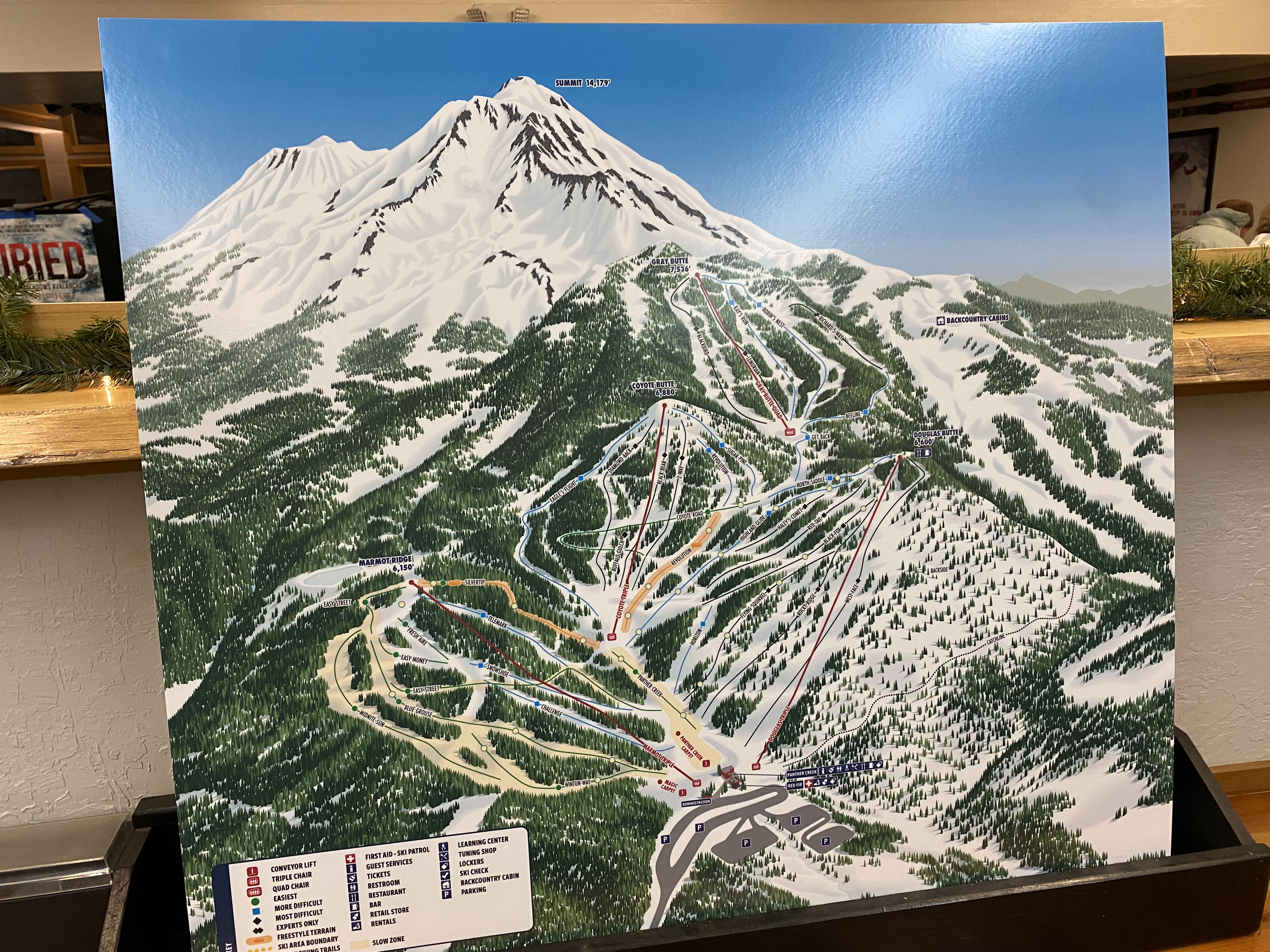
- Mt. Shasta unveils a new map showing the expansion onto Gray Butte.
- HTI Group celebrates 80 new ropeways installed this winter across its Leitner, Poma, Bartholet and Skytrac brands.
- Completion of the Lenawee Express at Arapahoe Basin is now expected in mid-December.
- Indy Pass adds Peek’n Peak, New York and Tussey Mountain, Pennsylvania.
- Doppelmayr shares energy saving operational tips with customers in Europe.
- Waterville Valley and MND postpone the load test of Tecumseh Express by a week due to delayed electrical components.
- Loon Mountain expects to open the delayed Seven Brothers some time in December.
- Sunday River plans a December 17th grand opening for Jordan 8.
- The operator of the Goldbelt Tram may invest $10 million in Eaglecrest’s pulse gondola project.
- Sterling Vineyards previews the first Omega V cabins coming to California.
- Kimberley spins the Northstar Express for the first time in nearly a year, hopes to open by the third week in December.
- The Village of Taos Ski Valley declines to sell a parcel needed for a base to base gondola, wants an easement instead.

I just hope that Kimberley has taken some counter measures to protect their lifts and don’t have the same issue as that sea to sky gondola. Someone definitely has it out for Kimberley
LikeLiked by 2 people
Problem…Mt. Shasta map doesn’t show access to Gray Butte from either Coyote and/or Douglas Butte.
LikeLike
I think the backside of Coyote Butte is an entirely open face, so you can see the bottom terminal of Gray butte from the top of Coyote. They’ll probably just groom a path straight down that face, but couldn’t show it on the map without too much distortion.
LikeLike
It is not a distortion issue. The backside of coyote leading to Grey Butte is on National Forest Land and they never got a permit to build trails, in fact it looks like they went out of their way to avoid this. But it is public land so you can ski it and it was regularly skied even before the new lift, maybe they will even groom it now. The rest of the Ski Park including both Coyotee and Grey is on private land except the access road which is on National Forest.
LikeLike
Kind of a bummer as the backside of Coyote was a great place to find left over snow. The backcountry warning at the top and flat cat track out kept most folks away.
LikeLike
I skied grey butte today and getting over and back is just a mess. Getting over requires going out of bounds thru gates and skiing a really steep run they can’t groom. Super fun today in all the snow be awful in leaner times. It was just carnage first thing this morning of unqualified skiers/riders trying to go over. When I went back later they were warning people in addition to signs how steep it was. No intermediate skier could do it on the regular. Getting back is literally a 10+ minute hike. They tell intermediate skiers to do that hike in reverse to get there.
LikeLike
That new Mt. Shasta trail map is probably my favorite VistaMaps trail map. But as Randy pointed out, it isn’t made clear how to get to the Gray Butte lift!
LikeLike