- Smugglers’ Notch abandons plans for a gondola to Stowe.
- Marmot Basin removes the long-closed Caribou double.
- Whitewater names its new quad Raven, posts an expansion map.
- Boyne Mountain’s new map shows two new lifts.
- Ditto for Sun Valley.
- Winter Park’s 23-24 map shows the new mid-station for Wild Spur Express.
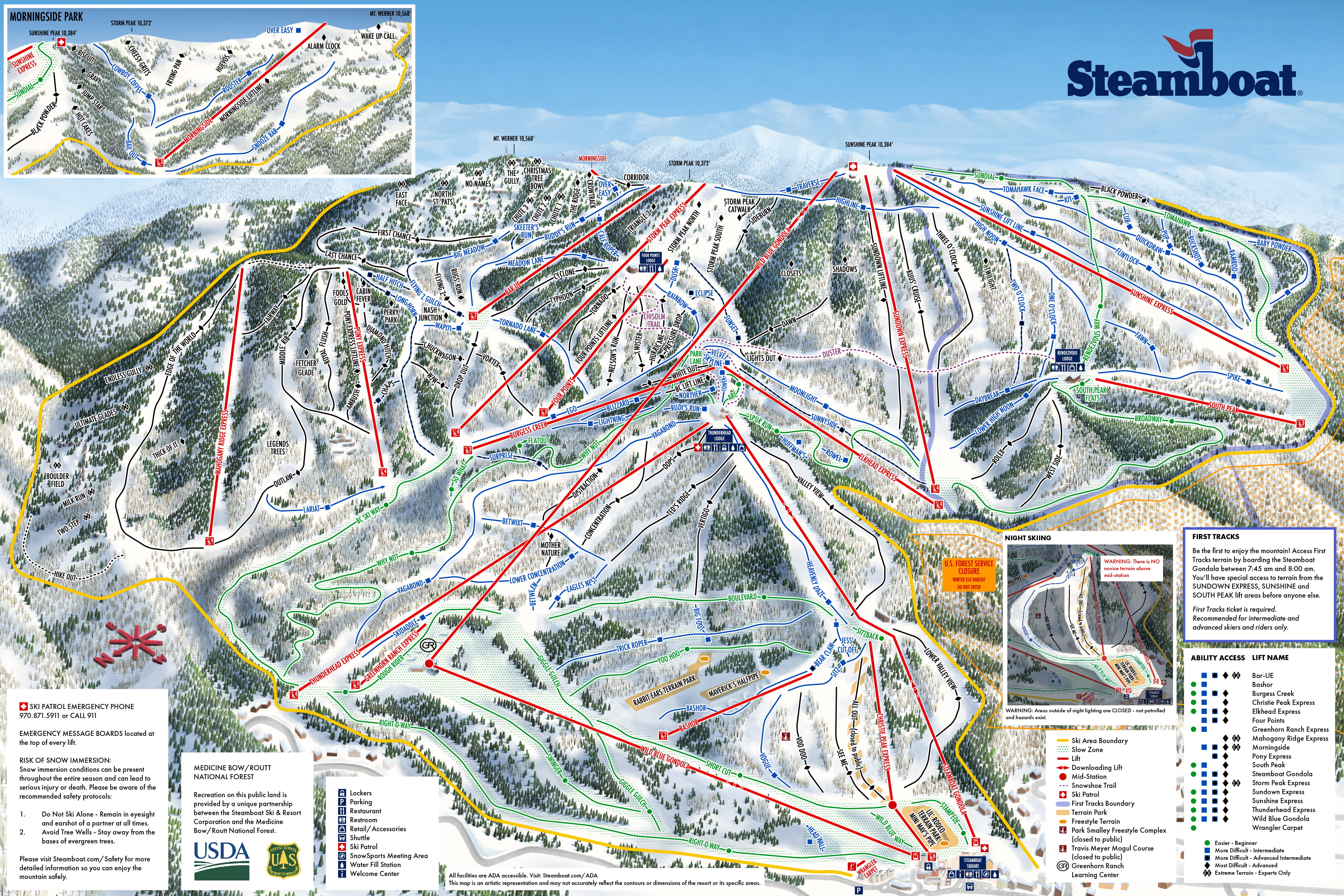
- Steamboat introduces a completely new map with Wild Blue and Mahogany Ridge.
- Steamboat begins testing Wild Blue II a.k.a. The Monster.
- Cooper and Mt. Shasta join the Powder Alliance.
- More than 50 new resorts will join the Indy Pass next week, including Great Bear, South Dakota.
- The No Boundaries Pass says Indy Pass banned its resorts from participating.
- Lost Colorado area St. Mary’s Glacier goes up for sale.
- Windham Mountain rebrands as Windham Mountain Club, will no longer sell single day tickets during peak periods.
- The Forest Service says it’s working with Montana Snowbowl to correct lift issues from last season before winter.
- Doppelmayr turns 130.
- An Ontario mountain needs a $100,000 lifeline to operate this winter.
- The Summit at Snoqualmie will sell chairs from the old Easy Rider triple.
- Rabbit Hill, Alberta moves lift towers due to ground movement.
- The Okanagan Gondola project continues to move forward in British Columbia.

The new steamboat map is WAY more ugly in my opinion. The old one was actually really pretty.
LikeLiked by 1 person
Both are nice, but I think the main idea here is for it to be hand-painted. Since Niehues retired and even before that so many places (even Steamboat) are using digital maps. It’s just really nice to have them created by a human rather than a computer.
LikeLike
Last years one was made by VistaMap which is computer generated. This years map is off brand for some reason. The James Niehues maps are definitely the best though.
LikeLike
There’s a reason I love Breckenridge’s decision to ditch the digital map for a James Niehues map in 2016, and Keystone keeping the painted map for the Bergman expansion.
LikeLike
It’s pretty tough to fit Wild Blue onto the map in a way that makes sense.
I’m not sure if it was confirmed that Fish Creek Canyon would be inbounds, but I’m very glad to learn that it is! Steamboat has steeps now!
LikeLike
It looks like you may have to traverse back from Mahogany Ridge Express.
LikeLike
While I’m sure you can also make your way across the trees between Middle Rib and the new chair, most skiers who should be on that terrain don’t have a problem with traverses. You get a lot of practice with them very quickly, and they just become part of accessing terrain we like to ski.
LikeLike
I agree, generally speaking I love hand painted maps but the perspective on this one is awful and it looks like a cheap knockoff of a Niehues or Rad Smith painting. Would have really liked to see Smith re-paint Niehues’ Steamboat map from the early 90s.
LikeLike
https://www.sundialhotel.com/webcam
Meanwhile in Whister, Excalibur going Park City red to match the new Fitz 8
LikeLike
That’s awesome. I’m up for Thanksgiving as it’s the last weekend for mtbing. I hope Whistler ends up doing more 8-pack upgrades
LikeLike
The Roundhouse as well as the Christmas lift are both accessible from the top of the new Flying Squirrel lift by means of Roundhouse Lane, is that correct?
LikeLiked by 1 person
That is correct
LikeLiked by 1 person
This means that when Challenger is down, Flying Squirrel can still be used to get to the summit in conjunction with Lookout Express or Christmas.
LikeLike
And the Greyhawk trails can be reached from Flying Squirrel as well, via Pete’s Lane to Middle Warm Springs, as an alternative to Challenger’s midstation.
LikeLike
If you can find Pete’s Lane. Really easy to ski past
LikeLike
In case you haven’t seen this. Some interesting photos of splicing the haul rope.
https://idahonews.com/news/local/a-behind-the-scenes-look-at-the-installation-of-brundage-mountains-new-chair-lift
LikeLike
It is really sad to see how the Smuggs-Stowe connector lift was torpedoed by government officials who were clearly against the project on a personal level and never gave it a fair chance. It is a testament to how environmental impact studies and reviews are dismissed when inconvenient and only used when differing interests align.
LikeLike
Clearly shows that if not for those bureaucrats, the connector would be around. Looks like it would’ve basically run from the top of Sterling over to the top of Sensation.
LikeLike
That’s quite an assumption — this proposal has already been deeply unpopular to date among locals, Smuggs lifers, and the non-downhill skiers who use this area. Sterling Pond and the Long Trail are pretty sacred to a lot of Vermonters (most of whom aren’t buying an Epic Pass) so any connector proposal here is always going to be, justifiably, a source of significant drama. And it’s not like fitting a gondola terminal at the top of Sterling is going to be an easy, low-touch construction project.
LikeLiked by 1 person
Donald, every comment I saw on articles about the potential gondola was in opposition. Many locals clearly think it’s not a good idea.
Mountain communities have to walk a very fine line of development to support themselves, but also not destroying the appeal of the area in the first place. I’m about as YIMBY as it gets (my town has extraordinarily high home costs after all), but building something intended for tourists that scars historic community places and only benefits developers will never get community support, nor should it. I don’t think it’s fair to prioritize out of state corporate interests and wealthy tourists over local residents, and the gondola is a blatant example of that.
LikeLike
Pretty extreme take there. Vermont has a long history of environmental protection rules and the memo in question was drafted by career ANR civil servants, not a political appointee. The location of this project is always going to make it a difficult sell.
LikeLiked by 1 person